
Drones have become increasingly popular in the past few years. Not only are they great for surveying areas, but they are great tools for action photography as well. Drone apps exist to help users maneuver and use their drones better by providing necessary information and tools to help their pilots. Some apps are specific to a certain brand but there are also others that you can use for a variety of brands. For a drone pilot, it would be wise to have one of these apps on your mobile phone to help you plan and execute your flights.
In this article, we’ll be looking at some of the best drone apps that you can use to make your flight experience safer and better.
Also Read: 20 Best Camera Phones to Take Perfect Shots Worth Sharing (2021)
Inside This Article
Drone Apps: What Are They For?
Drone apps are essential to every pilot whether they are professionals or individuals who use drones for recreational use. You will need drone apps to help you make your flights run smoother and safer. Not only do they provide information such as weather forecasts and airspace information to make your flights safer; some apps also provide tools for photography and surveying purposes. Without these apps, your flights will either fail or you might get in trouble for accidentally flying into a restricted area.
With drone apps, pilots can plan their flight execution and ensure that their flights will launch without a hitch. The best drone apps even provide you with information on no-fly zones and help you inform nearby airports when you fly your drones. From essential flight information down to photography tools, there is an app for every drone pilot.
It helps to always be aware of certain parameters before flying your drones. On the photography side, these apps help you take better photos and tell you the best times to take them. Most importantly, no effort will be wasted when you use drone apps as you’ll be able to plan better with them.
The Best Drone Apps
Without further ado, here are some of the best drone apps that you can download for a better flight experience. Note that these apps will range from the traditional drone apps that provide safety and flight information to drone photography apps.
Also Read: Cell Phone Camera Lens Buying Guide: Best of the Best
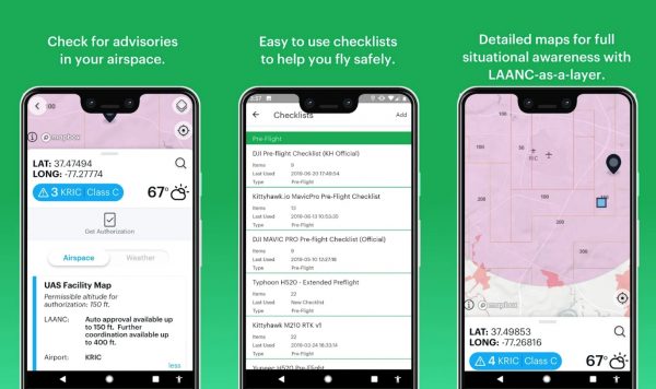
1. Aloft (Formerly Kittyhawk)
- Fly automated flights
- Plan missions
- Log flight data
- Run flight checklists and assessments
Aloft (a.k.a Kittyhawk) is one of the best drone apps to use for beginners who are just starting to learn the in and outs of drone flying. That said, it is an all-in-one app that seasoned drone pilots will also love. Aloft shows information about permissions and weather conditions. The app uses your phone’s location to help determine flight factors such as temperature, visibility, wind, daylight, humidity, and cloud cover. This app is also handy as it will tell you if you need any permits to fly a drone in a certain area.
Aloft also tracks your flights, helps with maintenance, and creates checklists for your flights. It’s one of the best drone apps that you can use for a better flight experience.
Download for Android (Play Store)
2. AirMap
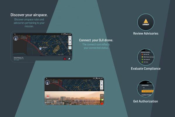
- Different map styles
- Create a detailed flight plan
- Sends a digital flight notice to select U.S. airports
- Lists airspace rules and advisories
AirMap is a very useful app especially for those living near airports. It has a Digital Notice and Awareness System that allows users to notify the nearest airport that they will be flying a drone. Apart from that, you’ll also have access to features such as tips and support, a list of AMA Fields, Night Mode, and Airspace information. It also monitors local air traffic and informs you if an airplane is in the vicinity.
The app was developed by the Federal Aviation Administration (FAA) which makes it an effective source for drone pilots.
Download for Android (Play Store)
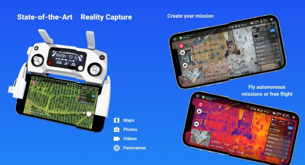
3. DroneDeploy
- Automatic flights and landing
- Provides an in-field data analysis
- Easily disable and enable auto flight
DroneDeploy is one of the more popular drone apps. This is a great app for pilots who intend to map out and create 3D models with photos from their drones. It gathers the necessary data that you’ll need including elevation, distance, and area. You’ll also be able to explore interactive maps and other 3D models.
Additionally, the app allows you to upload photos on its server and automatically analyzes them for you. After the analysis, you’ll receive detailed maps and measurements, among others. In all, it’s a great app for professional pilots and for those who enjoy 3D mapping.
Download for Android (Play Store)
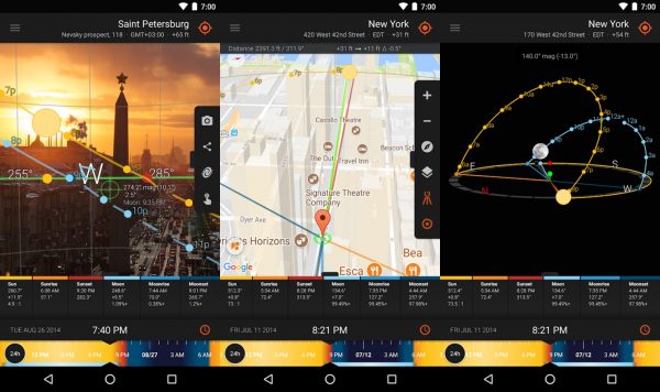
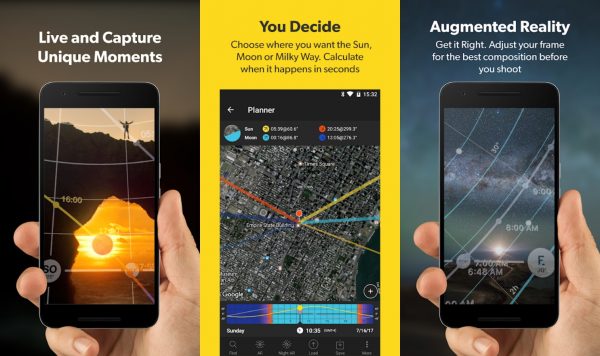
4. Sun Surveyor
- Provides the best times for photos
- Visual time machine
- Gives sun shadow information
- Provides different measurements including elevations and vertical angle differentials
Sun Surveyor is a great drone app for photographers. It helps detect “special stages” of the day such as the Golden and Blue hours that photographers sometimes struggle to chase. It provides users with real-time information on the positions of the sun and moon which will most likely help you plan your photoshoots.
Sun Surveyor mostly works as a pre-flight app to help you plan your flight but beyond that, it also has a Live Camera View, Interactive Map, and a 3D compass among its other features. The only possible downside of the app is that it’s not free (priced at $7.99) but it also has a Lite version that gives you access to basic features such as an interactive map, visual time machine, and sun shadow information.
Download for Android (Play Store)
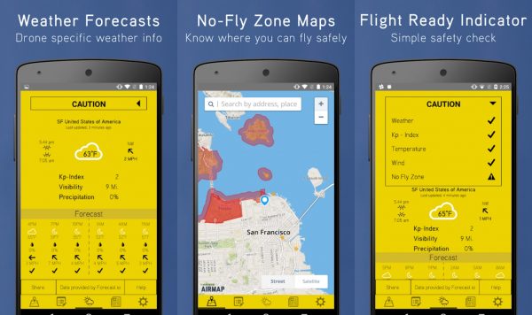
5. UAV Forecast
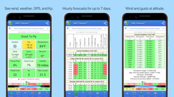
- Provides detailed weather information
- Hourly forecasts
- Gives information on No-Fly Zones
UAV Forecast eliminates the need for a manual analysis of the weather. It provides you with the most up-to-date weather information for your area. It also tells you whether it’s safe to fly or not. UAV Forecast also gives users an analysis of what can be classified as “good to fly.”
The app provides useful information for situational awareness such as wind speed, cloud coverage, visibility distance, and temperature. Overall, it makes flying drones simpler and easier as it provides you with the information you need to help make your flights safer.
Download for Android (Play Store)
6. B4UFly (Powered by Aloft)
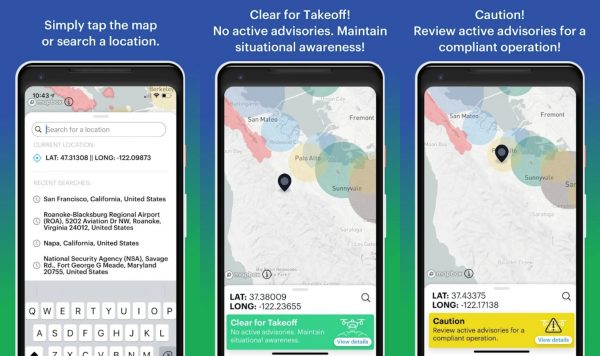
- FAA-approved application
- Provides FAA resources
- Gives airspace information
- Allows in-app access to the Low Altitude Authorization and Notification Capability when flying in controlled airspaces
B4UFly is a pre-flight drone app that makes checking airspace and local advisories easier. It provides you with the necessary information to stay compliant with certain laws before flying your drone. It also gives you airspace information that you need to know to make your flights safer.
This is one of the best drone apps as it provides users with official resources. It best works with the app Aloft. This app was developed as a partnership between the FAA and Aloft so it is surely of the best apps that you can rely on when taking flight.
Download for Android (Play Store)
7. DJI Go
- Free to use
- Automatically extract footage
- Dynamic map view
- Real-time flight records
This app is best for pilots flying drones made by DJI. The brand is one of the most popular names in the drone market so it’s no surprise that you might be piloting a DJI drone. Hence, this app is a great choice for you.
DJI Go has a lot of great features for drone photography. This includes control of its camera, a live HD camera, a library section to view your footage, and even a smart video editor. In all, it’s one of the best drone apps out there for recreational use.
Download for Android (Play Store)
8. Hover
- International No-fly Zone Map
- Provides Weather Data
- Access to flight logs
Hover is an app that takes information from AirMap. If you have extensive flight plans, this is a great app to have as it tells you whether or not it’s safe to place in your current location. It gives you a weather forecast as well as air traffic information.
If you’re looking for a drone app that’s simple and easy to use, Hover is your best bet. While it doesn’t have extensive features, it’s great for those who are looking for an app with a simple interface that’ll provide them with the basic information that they need.
Download for Android (Play Store)
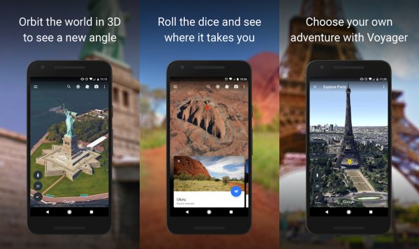
9. Google Earth
- Explore different geometry patterns
- Best for planning flights
- User-friendly
One of the apps that you might not expect to find on this list is Google Earth. This makes for a great companion especially when you’re planning your flights. It might not have the features intended for drones such as airspace information or safety assessments. But Google Earth is great for recreational use and for those who need an extra hand in preparing for photoshoots.
Google Earth helps you plan your flights by showing you a view of what you can expect from a certain area. It shows you the landscape and helps envision what your flight will look like. It’s an app that’s flexible enough that you can work around it and use it for different drones.
Download for Android (Play Store)
10. PhotoPills
- 2D Map-Centric Planner
- Location scouting tool
- Sun and Moon alignments finder
PhotoPills is one of the best camera drone apps in the market today. It has a wide range of features that you can use and exhaust for photography. It serves as your assistant to taking some of the best photos imaginable.
Its notable features include a location scouting tool, calculators, a photo plans manager, and even a set of calculators. Additionally, it provides you with information on the sunrise/sunset, Supermoon dates, Golden and Blue hours, and even moonrise/moonset times. It’s one done camera app that you’ll find helpful whether you’re a beginner or a professional.
Download for Android (Play Store)
Fly Safely with Drone Apps
Drone apps are essential to have for every drone pilot. They help in a variety of ways and they can also provide you with the necessary information to make your flights better. With these apps, you won’t run into the risk of wasting time and effort when things don’t go too well. Since these apps help you plan better, you can also execute your flights better. Ultimately, having one or two of these apps on your phone will help make your flight experiences better.