
Google Maps, the world’s most popular navigation app, has recently introduced a highly anticipated feature that brings even more convenience and safety to its users. In a remarkable update, Google Maps now displays speed limits and speed camera locations in real-time. This breakthrough enhancement allows drivers to stay informed about the speed limits on their route and avoid any potential traffic violations. By incorporating this functionality, Google Maps is empowering drivers to make smarter decisions while ensuring road safety. Whether you are embarking on a long road trip or simply commuting to work, having access to accurate and up-to-date speed limit information can significantly improve your driving experience. In this article, we will delve into the details of this exciting feature, its benefits, and how it can enhance your navigation experience. So, let’s buckle up and discover how Google Maps is taking your driving experience to the next level!
Inside This Article
- Overview of Google Maps
- Integration of Speed Limits
- Displaying Speed Camera Locations
- Conclusion
- FAQs
Overview of Google Maps
Google Maps is a widely popular and powerful mapping service developed by Google. It provides users with comprehensive information about geographical locations, directions, traffic conditions, and much more. With its intuitive interface and plethora of features, Google Maps has revolutionized the way we navigate and explore the world around us.
Whether you’re planning a road trip, looking for a nearby restaurant, or trying to find the fastest route to your destination, Google Maps has got you covered. It offers real-time traffic updates, satellite imagery, street view, and turn-by-turn navigation instructions to ensure a smooth and hassle-free travel experience.
One of the key strengths of Google Maps is its ability to integrate seamlessly with other Google services, such as Google Search and Google Earth. This integration enhances the overall user experience and allows for a more immersive and personalized mapping experience.
Moreover, Google Maps boasts a vast database of points of interest (POI), including restaurants, hotels, gas stations, hospitals, and more. It also provides information about public transportation options, including bus stops, train stations, and subway lines, making it a valuable tool for both commuters and travelers.
Google Maps is available on various platforms, including web browsers, Android devices, and iOS devices. Its cross-platform compatibility ensures that users can access and utilize the service regardless of their preferred device and operating system.
Overall, Google Maps has become an essential tool for navigation, local search, and exploration. Its user-friendly interface, accurate mapping data, and continuous updates have solidified its position as the go-to mapping service for millions of people worldwide.
Integration of Speed Limits
One of the most anticipated features in Google Maps is the integration of speed limits. With this new update, users can now easily see the speed limit of the road they are traveling on, right on their mobile devices. This information is displayed directly on the map, providing real-time data to help drivers stay within the legal speed limits.
By integrating speed limits into Google Maps, the app aims to promote safe driving practices and reduce the risk of accidents caused by excessive speeding. This feature is particularly useful for drivers who are unfamiliar with the roads they are traveling on or when driving in new areas.
Google Maps uses a combination of data sources to provide accurate and up-to-date speed limit information. It leverages information from authoritative sources, such as local transportation authorities and government databases, to determine the speed limits. Additionally, user contributions are also taken into account in order to keep the data relevant and updated.
When a user is navigating using Google Maps, the app constantly displays the speed limit of the road on the screen. The speed limit is shown in a clear and easy-to-read format, ensuring that drivers can quickly and easily adhere to the posted limits. This feature not only promotes safe driving but also helps drivers avoid speeding tickets and potential legal issues.
Moreover, Google Maps provides audio and visual warnings if a driver exceeds the speed limit. This proactive approach further reinforces the importance of obeying speed limits and encourages responsible driving habits.
The integration of speed limits in Google Maps has been widely appreciated by users around the world. It has quickly become an essential tool for daily commutes, road trips, and even in unfamiliar territories. With this valuable feature, drivers can confidently navigate the roads while staying within legal speed limits, enhancing overall safety on the streets.
Whether you are cruising on the highways or meandering through city streets, Google Maps’ integration of speed limits ensures that you have the necessary information to drive safely and responsibly.
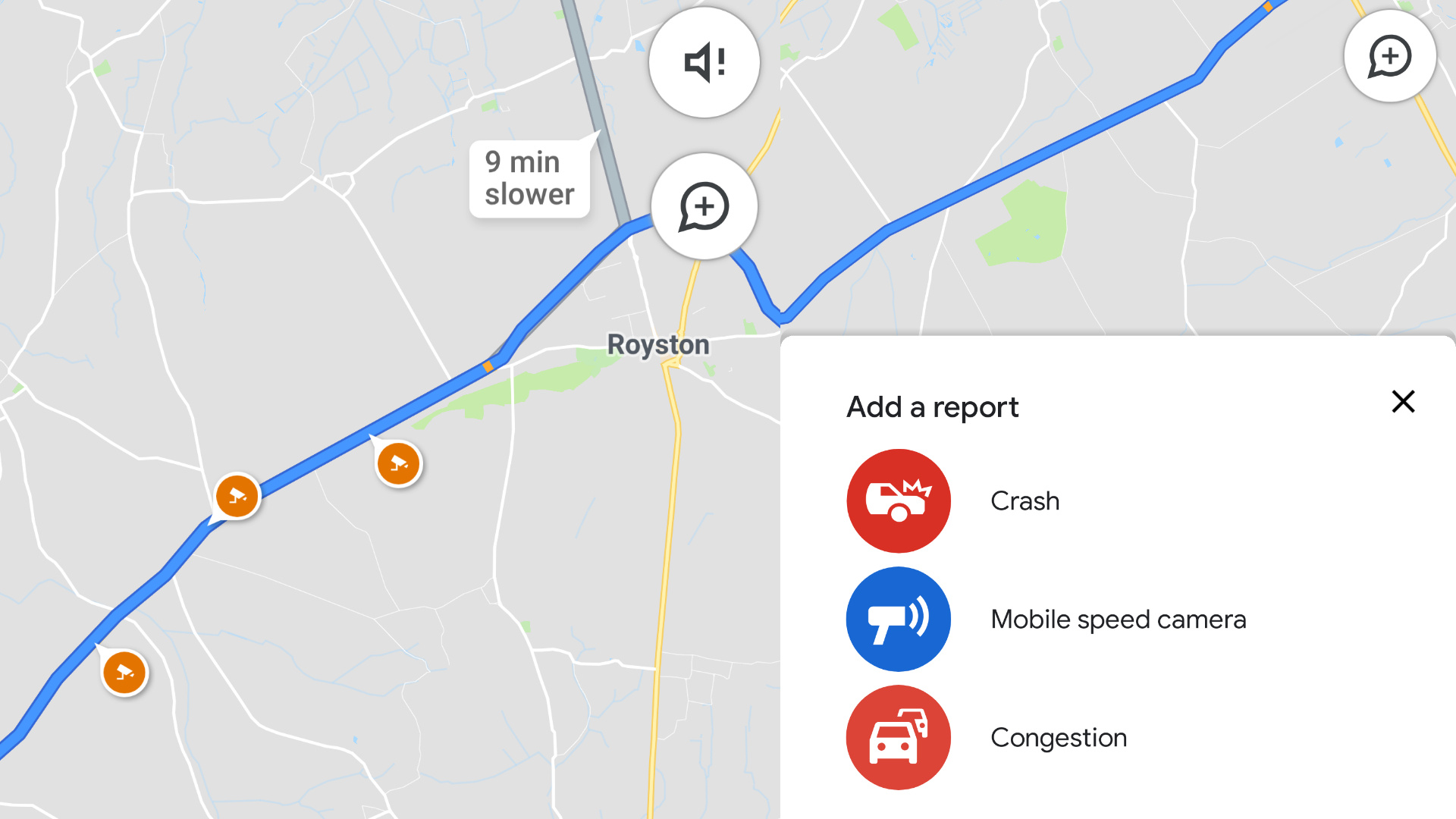
Displaying Speed Camera Locations
One of the most recent and useful updates to Google Maps is the ability to display speed camera locations. This feature has been highly anticipated by drivers who are conscious of following traffic laws and staying safe on the road. With Google Maps, users can now see the locations of speed cameras along their route, helping them stay aware and avoid any potential fines or penalties.
The speed camera location feature is especially valuable for drivers who are traveling in unfamiliar areas or are on long road trips. By having this information readily available, they can adjust their speed and driving behavior accordingly, ensuring compliance with speed limits and reducing the risk of accidents.
This innovation in Google Maps comes as a significant benefit to drivers, as it helps them stay informed about potential speed cameras without relying on external navigation tools or manually searching for speed camera locations. With a simple glance at the Google Maps interface, users can see markers or icons indicating the presence of speed cameras along their route.
In addition to displaying speed camera locations, Google Maps also provides additional information about speed limits in certain areas. This integration with speed limits and speed cameras creates a comprehensive experience for drivers, empowering them to make informed decisions while navigating the roads.
The accuracy and reliability of Google Maps’ speed camera location feature has been a subject of discussion among users. Google strives to provide the most up-to-date information, but it’s important to note that the availability and accuracy of speed camera data may depend on various factors, including local regulations and user-reported feedback.
As the Google Maps community continues to provide feedback and report speed camera locations, the accuracy of the information will likely improve over time. Users are encouraged to contribute to this community effort, helping fellow drivers by reporting any changes or additions to speed camera locations.
Conclusion
In conclusion, Google Maps’ new feature that displays speed limits and speed camera locations is a significant step forward in improving user safety and convenience. By providing real-time information about speed restrictions and speed traps, Google Maps helps drivers stay informed and avoid potential penalties or accidents. This feature contributes to a safer and more efficient driving experience, empowering users to make informed decisions and navigate their surroundings with ease. Additionally, the integration of these features directly into the Google Maps app eliminates the need for additional apps or devices, making it even more convenient for users. With Google Maps’ continued commitment to innovation and user satisfaction, we can expect more exciting developments in the future to enhance our navigation experiences.
FAQs
1. Can I use Google Maps to see speed limits and speed camera locations?
Yes, with the latest update, Google Maps now displays speed limits and alerts users about speed camera locations.
2. How does Google Maps know the speed limits and speed camera locations?
Google Maps gathers speed limit information from a variety of sources, including government databases, official signage, and user feedback. The data on speed camera locations is sourced from governments and local authorities.
3. What are the benefits of knowing speed limits and speed camera locations on Google Maps?
By displaying speed limits and speed camera locations, Google Maps helps users adhere to legal speed limits, promoting safer driving and reducing the risk of accidents. It also enables drivers to anticipate and adjust their speed to avoid traffic violations and potential fines.
4. Can I report inaccuracies in the speed limits or speed camera locations on Google Maps?
Yes, you can report discrepancies in speed limits or speed camera locations by using the “Report a problem” feature in Google Maps. This allows users to contribute to the accuracy of the data and provide feedback to improve the navigation experience for everyone.
5. Does Google Maps provide real-time updates on speed camera locations?
Google Maps provides real-time updates on traffic conditions, but the information regarding speed camera locations may not always be in real-time. However, the app can notify you about the presence of a speed camera based on the available data.