
Welcome to our guide on how to view photos by location on a map with your iPhone or iPad! Are you tired of searching through endless photo albums trying to remember where certain pictures were taken? With the power of location services on your iPhone or iPad, you can now easily organize and browse your photos by their geographical location. Whether you want to relive memories from a vacation, track your photography outings, or simply explore your photo collection in a unique way, this feature is sure to enhance your photo-viewing experience. In this article, we will walk you through the step-by-step process of accessing the map view in your Photos app, viewing photos by location, and even searching for specific places. So, grab your iPhone or iPad and let’s dive in!
Inside This Article
- Enabling Location Services
- Opening the Photos App
- Navigating to the Places Tab
- Viewing Photos by Location on the Map
- Conclusion
- FAQs
Enabling Location Services
Location Services is a feature on your iPhone or iPad that allows apps to access your device’s GPS information. By enabling Location Services, you can make use of various location-based features, such as viewing photos by location on a map. Here’s how to enable Location Services:
1. Open the Settings app on your device.
2. Scroll down and tap on “Privacy”.
3. In the Privacy settings, tap on “Location Services”.
4. Make sure that the switch next to “Location Services” is turned on. If it’s already on, you can skip to the next step.
5. Scroll down and look for the “Photos” app in the list of apps that have requested access to your location. Tap on it.
6. Choose the “While Using the App” option to allow the Photos app to access your location only when you are actively using the app.
7. Exit the Settings app.
By following these steps, you have successfully enabled Location Services for the Photos app on your iPhone or iPad. Now you can proceed to the next step of viewing photos by location on a map.
Opening the Photos App
Once you have enabled Location Services on your iPhone or iPad, you can now proceed to open the Photos app to view your photos by location on a map. The Photos app is a pre-installed app on your iOS device and can typically be found on your home screen.
To open the Photos app, simply tap on the Photos icon, which resembles a multi-colored flower. Once tapped, the app will launch, and you will be greeted with the main interface displaying your photo library.
If you have a large collection of photos, it may take a few moments for the app to load all the images. Please be patient while the app retrieves your photos.
Ensure that you have granted the Photos app access to your photo library, as it will allow the app to fetch and display the photos stored on your device. If you have not granted access, you may be prompted to do so when opening the app for the first time.
Once the Photos app is open and your photos have been loaded, you are ready to proceed to the next step of viewing your photos by location on the map.
Navigating to the Places Tab
Once you have enabled Location Services on your iPhone or iPad and opened the Photos app, it’s time to navigate to the Places tab. This tab allows you to view photos based on their location, displayed on a map for your convenience.
To access the Places tab, tap on the “Albums” tab at the bottom of the screen. From there, scroll down until you find the “Places” option and tap on it. The Places tab is denoted by a map icon, and it’s the perfect tool for exploring your photos based on where you captured them.
Upon selecting the Places tab, you will be presented with a map interface. The map will display various pins and clusters that represent the locations where your photos were taken. You can zoom in or out on the map to get a closer look at specific areas or get a broader view of your photo locations.
By default, the map will display the clusters of photos based on general geographical regions. As you zoom in, the map will display more specific clusters and individual pins for each location where you’ve taken photos. This allows for easy navigation and exploration of your photo collection based on their geographic context.
Additionally, you have the option to switch between the map view and the satellite view. The satellite view provides a more detailed and realistic representation of the landscape where your photos were captured. To switch between the two views, simply tap on the “Map” or “Satellite” button at the bottom left corner of the map.
Once you have accessed the Places tab and familiarized yourself with the map and its features, you are now ready to explore your photos based on their location. With a simple tap on any pin or cluster, you will be able to view the photos taken at that specific location.
Navigating to the Places tab and utilizing its map interface gives you a unique and enjoyable way to rediscover your photo memories. So, start exploring your photo collection and relive those special moments by location with the iPhone or iPad.
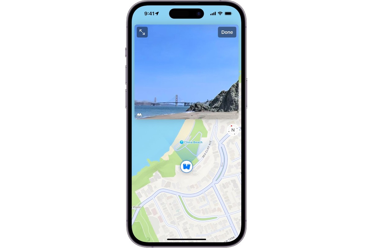
Viewing Photos by Location on the Map
Once you have enabled Location Services and opened the Photos app on your iPhone or iPad, you can easily view your photos by their location on a map. Follow these steps to view your photos by location:
1. In the Photos app, navigate to the “Places” tab located at the bottom of the screen. This tab is represented by a small map icon.
2. Once you are in the “Places” tab, you will see a map view with clusters of photos displayed at different locations. These clusters indicate the presence of multiple photos taken in that particular area.
3. You can zoom in and out of the map by pinching or spreading your fingers on the screen. This allows you to explore different areas and get a closer look at specific locations.
4. To view the photos from a particular location, simply tap on the cluster of photos. The cluster will expand, showing all the individual photos taken in that area.
5. By tapping on a single photo, you can enlarge it and swipe through the other photos taken at that location. This way, you can easily browse through your photos and relive your memories based on where they were captured.
6. You can also use the search bar at the top of the screen to find specific locations or places that you want to explore. Simply enter the name of the location, and the map will zoom in and highlight that area, displaying the photos taken there.
7. To exit the map view and return to the default Photos view, simply tap on the “Photos” tab located at the bottom of the screen.
Viewing your photos by location on a map is not only a fun way to retrace your steps and relive your memories, but it can also be a useful tool for organizing and managing your photo collection.
So, go ahead and explore your photos by location on your iPhone or iPad, and let the map guide you through your visual journey!
Conclusion
In conclusion, viewing photos by location on a map with your iPhone or iPad is a convenient and engaging way to relive your memories and explore the places you have been. By utilizing the built-in features of your device, you can easily organize and access your photos based on their geographical location.
Whether you want to reminisce about a memorable trip or track your adventures, the ability to view photos by location adds a whole new dimension to your photo gallery. It allows you to discover hidden gems, revisit familiar places, and create a visual timeline of your experiences.
Remember to make sure that location services are enabled for your photos and utilize the various apps and tools available to enhance and customize your viewing experience. So go ahead and start exploring the world through your photo library with the power of location-based photo viewing on your iPhone or iPad!
FAQs
1. Can I view photos by location on my iPhone or iPad?
Yes, you can view photos by location on your iPhone or iPad. The Photos app on iOS devices has a feature called “Places” that allows you to view your photos on a map based on the location where they were taken.
2. How can I access the “Places” feature in the Photos app?
To access the “Places” feature, open the Photos app on your iPhone or iPad and tap on the “Albums” tab at the bottom. Scroll down until you see the “Places” album. Tap on it to view the map with your photos.
3. How can I search for photos by location in the Photos app?
In the “Places” album, you’ll see a map with clustered markers indicating the locations of your photos. You can zoom in and out of the map and tap on a cluster to see the photos taken at that location. You can also use the search bar at the top to search for specific locations or landmarks.
4. Can I view photos from a specific date or time on the map?
Yes, you can view photos from a specific date or time on the map. In the “Places” album, tap on the place or cluster where you want to view the photos. Then, tap on the “All Photos” option at the bottom to see all the photos taken at that location. You can then use the time and date filters at the top to narrow down your search.
5. How accurate is the location information for my photos?
The accuracy of the location information for your photos depends on the device used to capture them. If your iPhone or iPad has GPS capabilities turned on, the location information should be highly accurate. However, if the photos were taken with a camera without GPS or were imported from another source, the location information might not be as precise.