
Are you tired of getting lost or struggling to find your way around while using public transit? Thanks to the built-in feature of Apple Maps on the iPhone, you can easily get public transit directions to your desired destination. Whether you’re new to a city, traveling, or simply wanting to explore using public transportation, Apple Maps offers a convenient and user-friendly solution.
In this article, we will guide you through the process of accessing and using the public transit directions feature on the Apple Maps app. From finding the closest bus or train stop to getting real-time updates on arrival times, you’ll discover how to make the most out of this handy tool. So, grab your iPhone and let’s dive in!
Inside This Article
- # How to Get Public Transit Directions in Apple Maps on the iPhone
- Enable Location Services
- Open Apple Maps
- Enter Desired Destination
- Select Public Transit Option
- Conclusion
- FAQs
# How to Get Public Transit Directions in Apple Maps on the iPhone
Apple Maps is a powerful tool that can help you navigate through different modes of transportation, including public transit. Whether you’re in a new city or simply looking for an alternative to driving, Apple Maps can provide you with detailed and accurate directions to help you get to your destination using public transportation.
To get public transit directions in Apple Maps on your iPhone, follow these simple steps:
1. Enable Location Services
Before you can access public transit directions in Apple Maps, ensure that Location Services are enabled on your iPhone. You can do this by going to Settings, selecting Privacy, and tapping on Location Services. Make sure that the toggle switch next to “Location Services” is turned on. This will allow Apple Maps to determine your current location and provide accurate transit directions.
2. Open Apple Maps
Once you have enabled Location Services, open the Apple Maps app on your iPhone. The app icon features a simple map icon with a blue background.
3. Enter Desired Destination
In the search bar at the top of the Apple Maps screen, enter the address or name of the location you want to navigate to using public transit. As you type, Apple Maps will provide suggestions based on your input. Select the correct destination from the suggested options.
4. Select Public Transit Option
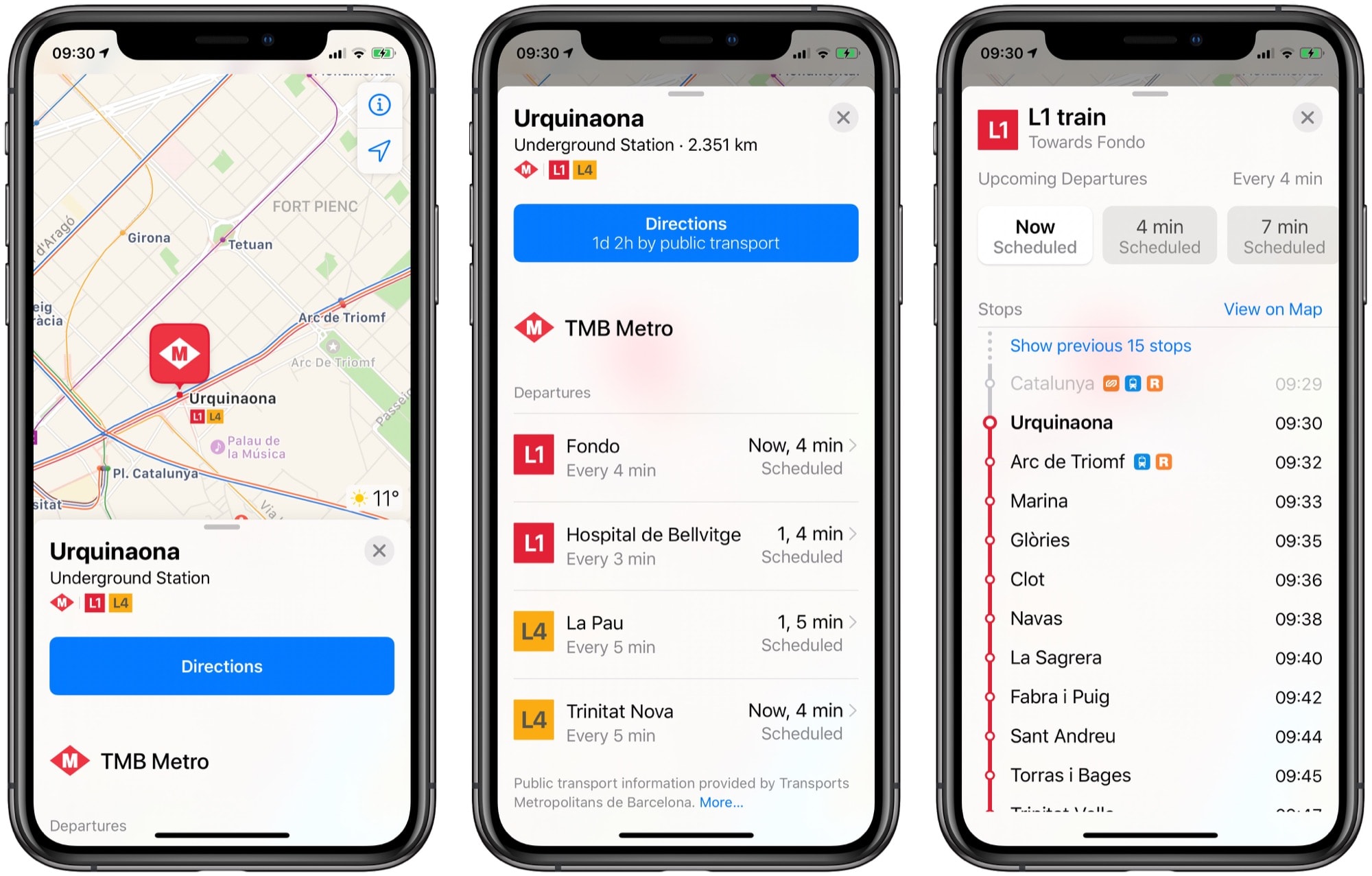
After selecting the desired destination, Apple Maps will display the route options available to you. Swipe up from the bottom of the screen to reveal a menu of transportation modes, including driving, walking, cycling, and public transit. Tap on the “Transit” option to view the public transit directions.
Apple Maps will now show you a detailed itinerary for your public transit journey, including the nearest bus stops or train stations, the expected travel time, and any necessary transfers. You can also tap on individual steps for more information, such as specific bus or train numbers, departure times, and walking distances.
By following these steps, you can easily get public transit directions in Apple Maps on your iPhone. Utilizing the power of Apple Maps will help you navigate the world around you and make your travel experience more efficient and convenient.
Enable Location Services
Before you can start using public transit directions in Apple Maps on your iPhone, you need to make sure that Location Services are enabled. Location Services allows your iPhone to determine your current location accurately and provide you with accurate directions.
To enable Location Services, follow these steps:
- Open the “Settings” app on your iPhone.
- Scroll down and tap on “Privacy.”
- Tap on “Location Services.”
- Make sure the toggle switch next to “Location Services” is turned on (green).
- Scroll down and find “Maps” in the list of apps.
- Tap on “Maps.”
- Select “While Using the App” to allow Apple Maps to access your location only while the app is open and active.
By enabling Location Services, you ensure that Apple Maps can accurately pinpoint your location and provide you with step-by-step directions for using public transit.
Open Apple Maps
If you want to get public transit directions on your iPhone, the first step is to open Apple Maps. Apple Maps is the default mapping app on iPhone, and it comes pre-installed with the operating system. You can easily access it by tapping on the Maps icon, which resembles a map with a location icon.
Once you open Apple Maps, the app will automatically detect your current location, provided that you have enabled location services on your iPhone. This is crucial for accurate transit directions, as the app needs to know your starting point to determine the best routes and transit options available.
Alternatively, if you want to get transit directions for a different location or plan your journey in advance, you can input your desired destination by using the search bar at the top of the screen. Simply type in the address or the name of the place you want to go to, and Apple Maps will provide you with relevant search results.
After entering your destination, Apple Maps will display a detailed map view with various icons and buttons. To access the public transit options, tap on the directions button located at the bottom of the screen. It is represented by an arrow inside a blue circle.
Next, you will be presented with a list of different transportation modes, including driving, walking, and public transit. You can tap on the “Transit” tab to specifically view and select public transit options. The app will show you available bus, train, or subway routes, along with estimated travel times and any transfers you may need to make.
Once you select a public transit route, Apple Maps will provide you with step-by-step directions, showing you the nearest bus stops, train stations, or subway entrances. You can also see the scheduled departure and arrival times for each transit leg, helping you plan your journey more efficiently.
Moreover, Apple Maps offers real-time updates for public transit routes, so you can stay informed about any delays or changes in the schedule while you’re on the go. This feature ensures that you have the most up-to-date and accurate information at all times.
With Apple Maps, getting public transit directions on your iPhone has never been easier. Whether you’re exploring a new city or just trying to navigate your daily commute, this handy app will help you reach your destination using the most convenient and efficient means of public transportation available.
Enter Desired Destination
To get public transit directions in Apple Maps on your iPhone, you first need to enter your desired destination. This can be done by following these simple steps:
- Launch Apple Maps: Open the Maps app on your iPhone. You can usually find it on your home screen or in the app drawer.
- Tap on the Search Bar: At the top of the screen, you will see a search bar. Tap on it to initiate a search.
- Enter Your Destination: Type in the address, landmark, or name of your desired destination. As you type, Apple Maps will provide autocomplete suggestions to help you find your destination more quickly and accurately.
- Select the Correct Destination: Once you have entered the desired destination, a list of possible matches will be displayed. You can choose the correct location from the list that appears, ensuring you select the one that corresponds to your intended destination.
By entering your desired destination accurately, Apple Maps will be able to provide you with the most relevant and accurate public transit directions, ensuring you can navigate your way efficiently using public transportation.
Select Public Transit Option
Once you have entered your desired destination in Apple Maps, the next step is to select the public transit option. This will allow you to access directions specifically tailored for traveling by bus, train, or other forms of public transportation. Follow the steps below to select the public transit option on your iPhone:
- After inputting your destination, Apple Maps will display the available routes. Scroll through the routes and choose the one that best suits your preferences or requirements.
- Tap on the selected route to expand the details and see a preview of the journey.
- At the bottom of the screen, you will find several icons representing different modes of transportation. Look for the one that resembles a bus or train, which indicates the public transit option.
- Tap on the public transit icon to view the specific directions and estimated travel times.
Apple Maps will now provide you with step-by-step instructions for navigating using public transit. This includes information on which mode of transportation to take, where to board, any transfers that may be necessary, and the estimated arrival time at each stop along the way.
Furthermore, the public transit option in Apple Maps often includes real-time updates on delays or disruptions, allowing you to plan your journey accordingly and avoid any unexpected inconveniences. This feature ensures that you have the most up-to-date information to make your public transit experience as seamless as possible.
So, whether you’re exploring a new city or simply trying to navigate your daily commute, Apple Maps provides an intuitive and user-friendly way to access public transit directions from your iPhone.
Conclusion
Obtaining public transit directions through Apple Maps on your iPhone has never been easier. With the intuitive interface and comprehensive database, you can navigate cities and towns, whether familiar or new, with confidence and ease.
By following the simple steps outlined in this guide, you can ensure a smooth and hassle-free journey using public transportation. No more confusion or delays, as Apple Maps provides accurate and up-to-date information on schedules, routes, and estimated travel times.
Remember to keep your iPhone updated with the latest iOS version and make sure you have an internet connection to access real-time data. Whether you’re commuting to work, exploring a new city, or planning a trip, Apple Maps is your go-to companion for seamless public transit navigation.
So, go ahead and make the most of this powerful feature on your iPhone. Get where you need to go, efficiently and confidently, with Apple Maps and its robust public transit directions.
FAQs
Q: How do I get public transit directions in Apple Maps on my iPhone?
A: To get public transit directions in Apple Maps on your iPhone, simply follow these steps:
- Open the Apple Maps app on your iPhone.
- Enter your desired destination in the search bar.
- Tap on the route button at the bottom of the screen.
- Choose the Transit option.
- A list of available transit options will appear. Select the one that best suits your needs.
- Apple Maps will then provide you with step-by-step directions to your destination, including walking directions to and from transit stations.
Q: Can I customize the public transit directions in Apple Maps?
A: Yes, you can customize the public transit directions in Apple Maps on your iPhone. After selecting the Transit option, you have the option to customize your route by adjusting your departure or arrival time, choosing a specific transit line, or filtering out certain types of transit (such as buses or trains). This allows you to tailor the directions to your specific preferences and requirements.
Q: Does Apple Maps provide real-time transit information?
A: Yes, Apple Maps provides real-time transit information, such as train or bus arrival times and service disruptions, when available. This ensures that you have the most up-to-date information on your public transit routes and allows you to plan your journey accordingly. However, it’s important to note that real-time information may not be available for all transit systems or in all regions.
Q: Can I use Apple Maps for public transit directions in different cities?
A: Yes, Apple Maps supports public transit directions in various cities around the world. However, the availability and level of detail may vary depending on the region. To check if public transit directions are supported in a specific city, you can search for that city in the Apple Maps app and see if transit options are available. If transit is supported, you can use Apple Maps to navigate the public transportation system in that city.
Q: Are public transit directions available offline in Apple Maps?
A: No, public transit directions in Apple Maps require an internet connection. This is because the app needs to access real-time transit data, including schedules, route information, and service updates. However, you can still view previously searched transit directions offline, as long as you have accessed them while connected to the internet. So, it is recommended to plan your transit routes before going offline to ensure you have the necessary information for your journey.